
As the title suggests, this edition of the blog comes to you from the Peruvian coast, Puerto Chicama to be more specific, where we’ll be spending the next 5 days surfing, swapping the sore legs for sore shoulders, but mostly relaxing hard. After nearly 4 months on the road, this break from the daily grind has been much welcome and will hopefully have us feeling refreshed, both physically and mentally, for when we climb back into the mountains.
There were a lot of unknowns when planning our route down to the coast; most tourers, especially those more focussed on the off-road side of things, tend to stick to the mountains going south from Cajamarca, so info on non-highway route options were pretty thin on the ground. In the end, I think we went through 3 different iterations before settling on our final route, which we hoped would balance efficiency (getting to the coast on the day we had actually booked our hotel) with the requirement to include as much off-road riding as possible. Still, our expectations were fairly low for this stretch of riding, which made the amazing roads and landscapes we encountered all the more special. Having 3000m net elevation to drop also helps, although I did manage to also sneak a 40km climb in there (sorry El)!
Out of Cajamarca, we wiggled our way up the hill to the South of town towards the archeological site at Cumbemayo. Wiggled being the operative word as the switchbacks were numerous and the gradient so pleasant after the vertical walls of Colombia and Ecuador. These Peruvians sure know how to construct a nicely graded road!


At the top, the rain was threatening and the wind was howling so we opted to forgo paying our 8 Soles to the enter the site itself and simply ride on through. Still, there were plenty of crazy volcanic rock formations (called “Los Frailones”) to gaze at as we made our way along the summit plateau, so we don’t really feel that we’ve missed out on too much.


Once over the top of the pass at 3700m (about 1000m above Cajamarca), we entered an impressive valley – bare rock walls on either side and gigantic boulders dotted amongst the fields. This should be a climbing Mecca if it isn’t already. A 2800m descent on dirt awaited us!


We stopped for a quick ice-cream and chat with the shopkeeper in the village of Chetilla, before continuing on downwards.

The rock formations in this valley continued to impress as we left Tuñad, the landscape getting drier and more barren with every passing kilometre.

Meanwhile, the colours on the next set of hills to our South, towards which we were riding, were going off in the rich evening light.


As dusk fell, we found a small flat space around 300m above the valley floor – far enough to be well away from the highway and the traffic along it, but close enough that we wouldn’t have to much more descending to do the following day. The view wasn’t too bad either!

Despite the fact that we’d be dropping around 2500m overall on this stretch to the coast, the following day would be almost entirely spent climbing! Such is the price you pay for seeking out the paths less beaten. From the Rio Magdalena (the 2nd such called river of our trip so far), it is nearly 2000m up to the town of Contumazá. Although the road is tarmac, which we’d usually try and avoid, the traffic was almost non-existent as it makes no sense for most people to drive up here.

Although never actually that hard, 40km of continuous uphill with the sun beating down on you eventually takes its toll. Nearing the top, a community police 4×4 from Contumazá driving in the opposite direction to us stopped and handed us both 2l of water, before doing a u-turn and heading back up the hill. Clearly word had got to the town that there were two crazy gringos grovelling their way up this climb and in need of assistance!

The small market town of Contumazá made an immediate impression on us when we rolled through its neat, colonial era streets towards the main square and it didn’t take much discussion before we agreed to spend the night in a hotel here instead of forging on to some as-yet unknown wild camp spot. With its over 100 year history and large banquet hall, Hotel Contumazá felt a lot like staying in one of those Victorian era hotels here in the UK, usually to be found at the seaside or in some spa town, whose glory days are clearly well in the past. Still, our room was big and clean, the price was cheap (40 Soles, approx. £9) and there was a hot shower to wash the salt off our bodies. We spent that evening eating ice cream in the main square, getting stared at by locals (we’ve sort of got used to it, but it seemed particularly bad here) and fruitlessly trying to find an open restaurant before eventually settling for the tried and tested papi-pollo (chicken and chips).
Much to El’s chagrin, there was more climbing to start the following day. This time on dirt, as the tarmac petered out 100m the other side of town.

Eventually, EVENTUALLY, we topped out at 3200m and there it was, the last ridge of the Andes snaking its way down into the mist and the ocean, far, far below.


The descent was another Peruvian corker.


600m down, we passed through Guzmango where some asking around got us an Almuerzo in what seemed like someone’s front room, but which was actually a restaurant (they don’t do signage here). Another 1000m later and we were in San Benito for an ice cream and water refill. Another 1000m and we were finally at the bottom, a land of dust, rock and cacti.


Despite having been descending all afternoon, the morning’s climbing efforts had taken their toll, so we opted to skip the final 350m climb on dirt and divert onto the tarmac road that parallels the Rio Chicama. We’d read and been warned previously that the Peruvian coast was not that safe and, as if on cue as we crossed the Rio Chicama, physically leaving the mountains behind and entering the coastal region, a moto rider pulled up to us and warned that we would probably get robbed if we didn’t get off the road before dark. Great! We generally take these warnings with a pinch of salt, since isolated incidents tend to get blown out of proportion, but we still breathed a sigh of relief when within half an hour of sunset we found, with thanks to the iOverlander app, a flat spot up a side canyon which couldn’t be accessed by vehicles and which couldn’t be seen from the road.
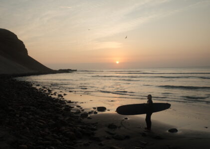
The nearly 100km covered the previous day had left us with a final 60km, slight downhill stretch to the edge of the ocean. For once on this trip, we exceeded our estimated speed and very nearly averaged 20km/h on this stretch, which meant we pulled in to Puerto Chicama and got our first sight of the ocean before it was even time for lunch. The speed with which this section passed was definitely the only positive thing to report back on, as the landscape adjacent to the Pan-Am highway was exactly what I’d image a post-apocalyptic world to look like – a world of dust, rubbish and scavenging dogs. Even if the economics (ie. incomes) might suggest otherwise, in each of the 3 countries we’ve visited so far, these lower elevation areas have always felt so much poorer and less appealing places to live than the highlands. What with the heat, the lack of water and all pervasive dust, and the heaps of smouldering rubbish strewn everywhere, we couldn’t help but feel very sorry for the people who have to call this place home.
By contrast to the towns along the Pan-Am, Puerto Chicama’s tourism dollars have made it feel a bit more loved and cared for. While the surf hasn’t quite lived up to the marketing hype, that’s probably for the better since we’re both pretty rusty. In between surf sessions, we’ve been getting to know a bit more about Viktor, our host here at Chicama Surf Camp. Originally from Lima, the family moved out here to give their son Cesar a healthier, more outdoorsy life – it seems to have worked so far as many of the allergies he experienced back in Lima miraculously went away soon after the move. They cultivate (probably the wrong word) crickets in small buckets filled with old egg boxes which they then take up to their farm in the Cordillera Negra (ie. a long way away) and use to feed the animals. Viktor spoke of how he’s been trying to get other farmers to adopt more sustainable practices for fertilising their crops and feeding their livestock, but they all just think he is loco. It seems that, sadly, the large agro-business firms have their claws well and truly into South America. Like everyone else we’ve met on our travels, his trust in the political system to act in the best interests of current and future generations is non-existent.
Anyway, enough of the doom and gloom. Desert beach life has been pretty sweet so far.


Routes
If you’re interested in our routes, you can find them all on our trip homepage.
The summer so far in Bristol has been 4 weeks of gray skies and rain.
Your blog’s really brighten up a very dull summer.
Views for days! Sounds and looks amazing.
Pingback: Buenas Piernas! - drawinglinesonmaps.com