It was always going to be a tough act to follow on from our Ausangate experience (in the last post) – that loop was about as good as high alpine mountain biking can get. Still, our 11 days riding from Chilca to La Paz (Bolivia), loosely following the Tres Cordilleras route, provided a multitude of contrasts which kept the interest going. From snow capped peaks to barren, windswept plains and the beginnings of the altiplano, from a brief diversion down to the start of the jungle to the positively Mediterranean shores of Lake Tititaca. These contrasts have really made it feel like we’re on a trans-continental trip after all, a feeling that often got lost when slogging up and down the endless series of similar high passes that have made up most of our riding down the central spine of Peru.
We arrived back in Chilca from the Ausangate loop at around 11am and, after re-packing the kit we had stored at the village shop and quickly downing a litre of yoghurt whilst sitting on a log, we were off again up another hill. Not the longest, with around 700m vertical difference, but it would mark the highest point (on bikes) of our trip so far at over 5000m above sea level.

After stopping for a brief roadside lunch accompanied by a couple of friendly sheep dogs, we tackled the remaining half of this pass. At this point, it started hailing ever so lightly, like nature was kindly hinting that we’d better get a move on and get over this pass before the real weather kicked in.


Once over the top, the landscape change completely; we’d left behind the deep river valleys and entered the wide open pampa. The swirling hail and distant thunderstorms made for one of the most incredible skies we’d ever witnessed.

Luck was on our side though as we only received a few drops of rain on our pitch by the a small stream in the middle of the expansive valley. With 180 degree views to snow capped mountains, it was quite the spot.

The following morning offered further incredible views North towards the Cordillera Vilcanota. In wide open places such as this, where it feels like you can see forever, I feel the edges of my being go a little fuzzy, as if I’m slowly dissolving and becoming part of the landscape. I think these might very well be my favourite places to ride through.


We stopped for a second breakfast/early lunch (not much difference in the offerings here) of the most delicious trout in the very isolated pueblo of Phinaya, watching as waves of local men came in to get their fizzy drink fix (the standard of dental hygiene being noticeably poorer in this corner of Peru than the other places we’ve visited). We both explained to the shop/restaurant owner that it was the best trout we’d eaten in our 6 months (we’ve eaten a lot of trout) and she explained that it was wild, rather than farmed as most of it is here. Mmmm, delicious.


Once again, we were chased off the pass by squalls of hail and a bitingly cold wind. We descended many, many kilometres that afternoon and camped just outside Corani, surrounded by impressive canyon walls on a pitch that was 90% of the size required for our tent. Still, it was not obviously visible from the road and the adjacent stone walls provided some modicum of shelter from the wind. Dirty bike tourers can’t always be choosers.
The following morning dawned grey and drizzly; one of the few occasions when we haven’t awoken to clear blue skies here in Peru. It took some extra motivation to get out of bed and begin, given that the day didn’t promise anything special on paper. Or so we thought…

To our pleasant surprise, the climb out of Corani took us through the most incredible valley filled with limestone cliffs and boulders. As El joked,
“This would be a world class climbing destination if it wasn’t in deepest, darkest Peru. Even Paddington, with his marmalade sandwiches, would struggle to get here”
The clouds cleared near mid-day and a strong tailwind blew us swiftly up the gloriously smooth tarmac road to Macusani, where we had planned a rest day. 7 days on the trot since Cusco had us both feeling a little spent. By the end of the first evening, we had sampled each of the towns three bakeries! Really, there was not a whole lot else to do in this isolated town which, although the regional capital, is a bit cold, windswept and just…uninspiring. Our second night in town was brightened up by the arrival of Brits Robbie and Izzy (our friends from Oyon and Cusco) who had been following our wheel tracks half a day behind and who we would hopscotch with all the way to La Paz.

The landscape changed notably and for good after Macusani – we were edging our way onto the Altiplano. This meant fewer hills (yay), but constant wind (boo). We spent that afternoon and the following morning fighting a vicious crosswind blowing down from the mountains, with only a brief stop in the town of Crucero for ice cream to give our legs a rest and ears a break from the white noise. We got chatting to a few locals as we toured the main square in search of a few supplies. When they found out where we would be passing through in a few days – Ananea – they warned us: “make sure you lock your bikes up there. They’ll steal them, just like they steal the gold”.
However, before that ominous fate awaited us, we’d planned a diversion off the 34K and its relentless wind, back onto the official Tres Cordilleras route as it dropped 1000m down into Cuyo Cuyo on the road to the jungle. Our target: some eagerly anticipated hot springs.
After a short 8km slog into a headwind now that we’d turned North, measured in a highly scientific manner at gale force 4 to 5 by assessing the white horses on the adjacent lake, we dropped down through an incredible landscape of pre-Incan terracing – by far the most extensive we’d seen so far. While we had known about these in advance, their shear scale, both in the vertical and horizontal planes, was truly impressive. What was sad though was how many of these have simply been left to go fallow. How much more food would have been produced locally back in the Incan and pre-Incan days, we wondered? The hills must have been quite a sight back then, covered as they would have been in people working the land.


We arrived into town to a parade of cholitas (old women, usually in traditional dress) who had flocked from all the surrounding towns to show off their backpacks of what we supposed would be their local, seasonal produce, but which many of them had strapped biscuits and crackers to!


After having a good chuckle, we pedalled up the hill towards the thermals. While cleanliness standards were typically Peruvian (ie. low), for 10 Soles (less than £2.50), we got to fill our own big bathtub with hot water to whatever temperature we felt like and slowly turn into prunes. Can’t complain really, especially since it was the first tub in nearly 20 years that I’ve actually managed to fit my entire body into.
The payback for all that over-indulgence at the hot springs was a 1000m climb back up onto the high plain. Luckily for us, the swirling clouds kept things nice and cool, since the gradients were often a little over our comfort thresholds.


Back on the altiplano, a scene of devastation awaited us. The area around Ananea has been completely descimated by gold mines, turning the hills into gigantic piles of slag and leaving mountains of plastic waste in their wake. The irony of seeing the familiar “Cuidamos del medio ambiente” signs along the roadside as we passed mine after mine for 20km straight seemed to be lost in the wind. The ultimate tragedy is that only a tiny proportion of the proceeds, the result of all this irreversible environmental destruction, actually stays within the local community – most is spirited away to the big cities and, often, out of the country to the ultimate investors in Europe and North America. We couldn’t wait to get out of sight of the place.


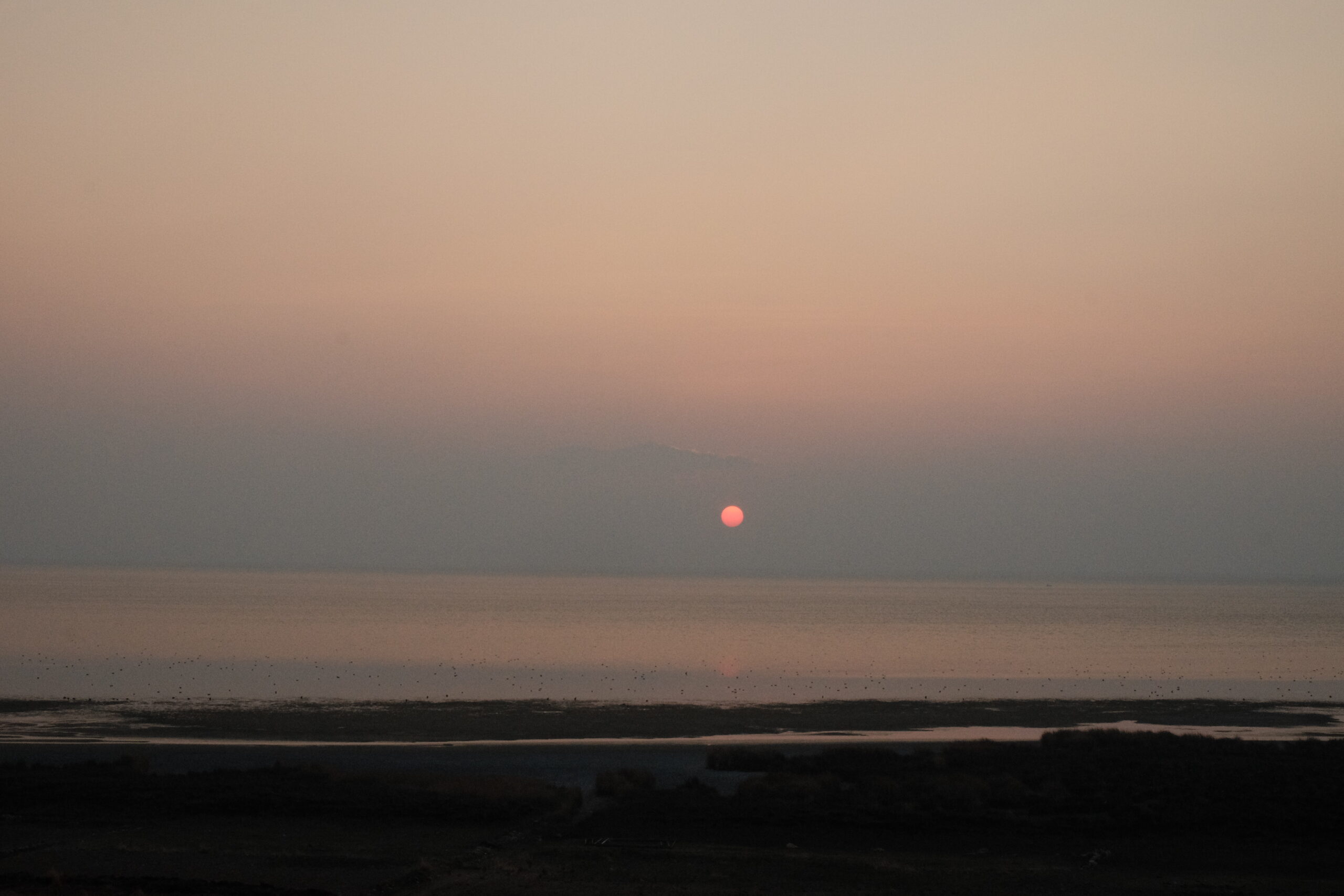
We followed the Peruvian – Bolivian border for the next couple of days, the Bolivian side often just the other side of a small stream, the wind still causing annoyance along with long stretches of bad washboarding. When would we get our first glimpses of Lake Titicaca we wondered? Not until the very last moment it turned out.


With its shimmering blue waters and multitude of islands, it could have been the Adriatic coast of Croatia. Or nearly, anyway. The 3800m elevation and constant wind that brought out goosebumps every time the sun momentarily disappeared behind a cloud meant the illusion was never quite total. We tucked into what we thought would be our last Peruvian almuerzo and headed to immigration. We already knew that we would have an overstay fine to pay since we’d been in Peru about 2 weeks longer than our 3 month visa. And since it was a Sunday, and we thought these fees could only be paid at the nearest Banco de la Nacion, were fully prepared to spend a night in town and get a collectivo first thing in the morning to the nearest big town – Moho.
However, the lady at the Migration said that this fee could also be paid online. The catch was that there was no Claro mobile signal to be had for miles around! The kind lady tried unsuccessfully to hotspot us and while the municipal Wi-Fi beamed out over the square, no one seemed to know the password. To frustrate matters, neither of the owners of the 2 hotels in town were anywhere to be found, so we just ended up spending the afternoon sitting the plaza, so close to being able to pay this fine and cross the border, yet so far.
To cut a long, frustrating story short, we did take a minibus to Moho the following morning to find a giant queue outside the bank, but Claro 4G signal! Thus, we ended up paying online after all! It took us 2 hours of waiting by the side of the road to find a minibus to take us back to Tilali, so we were both rather miffed when we finally got our passports stamped at 2pm that day. The benefit of this delay was that Robbie and Izzy had caught us back up again, so it was as a 4 that we pedalled the hilly 10-ish km between the Peruvian and Bolivian border controls and descended upon the immigration centre in Puerto Acosta.

It was with heavy hearts that we left Peru, a country that has provided so many memories and yet one in which we feel that we’ve barely scratched the surface, but the tug of a new country pulled us onwards. Bolivia awaited.
After making it clear that we were definitely not from the USA, the man at the immigration control’s manner seemed to soften and our entry into the country proceeded quickly; the main delay involving us attempting to explain the long winded country name. I mean, “United Kingdom of Great Britain and Northern Ireland”, who wouldn’t be confused?!
We camped just outside of town with Robbie and Izzy in a howling wind that had us questioning throughout the night if this was going to be it for our tent. Thankfully, the Tarptent is pretty sturdy, if a little flappy in the wind. We continued as a 4 the following day until Escoma where we parted ways – Robbie and Izzy having to resupply having been reduced to eating dry bread that morning – and kept plugging our way around the lake on a smooth tarmac road, the infernal wind still omnipresent. We’d hoped for a swim in the lake at some point, but the opportunity of a bank that wasn’t covered in reeds and/or super shallow and muddy never materialised, so we ended up riding a lot further than we’d expected to that day – 125km, our furthest day yet.
As the evening started to close in, we took a look at iOverlander and spotted a potential camp spot on Isla Cojata, a small island joined to the mainland by a causeway. This become our challenge as we raced the sunset.


As we we cycling back off the island, a local waved us down, his manner seeming not at all pleased.
“Who said you could stay here?”, he asked, aggressively.
“We asked the lady on the entry gate if we could camp last night”, we replied.
“Están mintiendo (you’re lying)”, he replied. Oh dear, this was not going well.
After establishing we were from England (easier than saying: United Kingdom Great Britain and Northern Ireland) and not the US, we managed to talk him around and actually had a really enjoyable conversation with him, discussing the differences between our countries and what we each did for a living. When I replied to the usual how-much-does-your-bike-cost question with a fairly low ball answer, El chipped in with “how many cows can you buy for that?”, causing much chuckling. One bull, it turns out.
We’d always planned to try and hitch the final stretch into La Paz as highway riding is not at all our idea of fun or a good use of our time and we were lucky to find an empty collectivo on the edge of Batallas that would take both us and our bikes. At mid-day, we found ourselves pedalling over the edge and into the huge bowl that the sprawling mass of humanity that is La Paz occupies. It was quite an assault on the senses; the noise, the smell and the insane traffic.
We’ve spent a fairly hectic day and a half here running errands and planning our onwards route, as well as spending a lovely dinner catching up with the bicycle touring community that currently finds itself here: 11 round a table – a new record for us.

We’re meeting up with a friend in San Pedro de Atacama in less than a month, so time is tight and we’re keen to hit the road again tomorrow. While we appreciate the creature comforts (mainly the food options) available in a big city, the chaos and pollution of La Paz doesn’t make us inclined to stay here any longer than required.
More wide open spaces await!
Routes
If you’re interested in our routes, you can find them all on our trip homepage.
Enjoy Boliva. We loved Sajama, Vicunas route and Salar Uyuni. The Lagunas route was not worth the suffering. We are home now waitig for the snow to come so we can play in th mountains. Take care. Danny
Thanks Danny, that’s pretty much our itinerary. Going to skip Lagunas as were low on time and you didn’t sell it to us back in Oyon!
Enjoy the snow!