I left Liam alone in the hotel reception in Caraz for five minutes… and when I returned our plans had changed!
With his phone in his hand exploring a digital map of our surroundings he was getting a strong fear of missing out. The Cordillera Blanca are part of the Andes and the most extensive tropical ice-covered mountain range in the world. The area contains several peaks over 6,000m including Huascarán, Peru’s tallest mountain, and over 500 glaciers. So to think that we were going to whistle through in 5 days’ cycling was almost a bit disrespectful! So in the grand scheme of a year-long trip spending a couple of extra days here was a bit of a no-brainier.


Close to Caraz lies a beautifully bright turquoise blue lake called Laguna Parón, and a few hundred meters higher up the mountain there is a glacier flowing directly into another lake, Laguna Congelada. It would be several months and deep into Patagonia before we’d see another glacier discharging directly into water. Plus it was an almost 2,000m climb up above Caraz so a good chance to warm up our legs and get a bit more altitude acclimatisation in before setting off on the Huascaran circuit.
In hindsight I’m so glad that we took the time to explore Paron and this side of the National Park because it was so empty compared to the next valley. While I do believe that, well managed, nature tourism is a force for good I’m still an old humbug at heart who enjoys wild places when they’re quieter. After a solid day of climbing we rode through the vertical granite walls that signal that you have arrived, not to Mordor, but to a valley more beautiful than Rivendell. We camped for free near the Refugio and posed for photos with some Peruvian tourists who clearly felt they’d lucked out to find a bonus couple of crazy gringos on their day out. After a quick sunset scramble to the mirador we settled down to a cup of tea made from Coca leaves and snuggled into our sleeping bags while our bodies were still warm from the walk.


The following morning we set off on our 15km ‘walk’ to Laguna Congelada and I quickly realised how well my body had adapted to riding at 4,000m by experiencing how poorly it was adapted to walking, scrambling and climbing at this altitude!


As we circumnavigated the turquoise blue laguna it was beautiful to see the surrounding mountains from new angles, seeing the shapes made by the ice on the jagged granite peaks. Less tranquil were the noises made by the movement of the glaciers, like a louder and more menacing thunder, as they move and rumble over rock. A little concerning when they’re towering above you! As we climbed, Laguna Artesoncocha came into view below us, probably frozen on the surface judging by the colour of the water.


At the end of Laguna Paron we pass by base camp for Artesonraju, the 6,000m peak above Laguna Congelada, and past some memorials to those who have died climbing this dangerous peak. A boulder with three plaques in memory of Czech mountaineers and a photograph of a Swiss trio who died descending the peak following a successful summit. Today the mountain is considered too dangerous to climb, climate change has made the ice too unstable.
Some 2 hours of steep hiking and scrambling from the end of Laguna Paron towards Artesonraju we finally got to see the glacier that terminates into Laguna Congelada. I’d heard of British mountaineer Joe Simpson descending Siula Grande (which we will see later in this trip) having broken into his leg, but I hadn’t appreciated how difficult it was to cross moraine (the rock debris deposited by a glacier) until now.

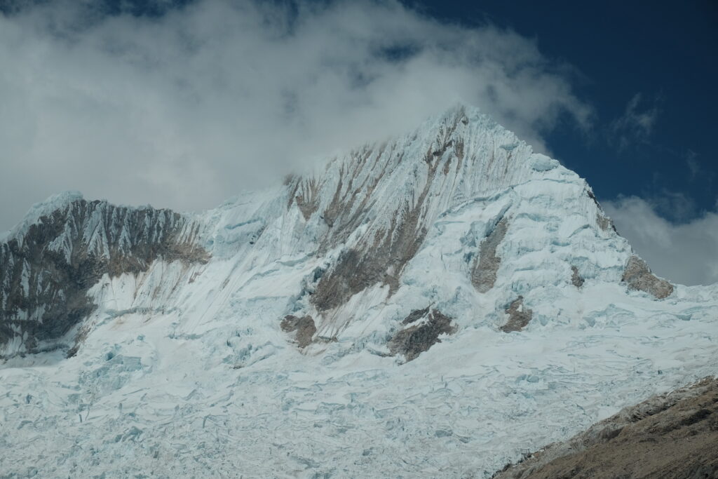
If Artesonraju looks familiar that’s because it is the mountain in the Paramount Studios logo that you often see at the start of films!

We enjoyed sandwiches of avocado and hard boiled egg in stale bread rolls and then something bizarre happened… Liam who isn’t usually one for acts of bravado and certainly isn’t normally a fan of cold water swimming, got in the lake so that I could take a photo! While I’m normally the one to wax evangelical about the joys of bathing in frigid cold water I was a little overwhelmed by the walk up and wanted full dexterity of my toes for scrambling back across the moraine. So I stayed wrapped up warm on the shore. Besides, someone had to take the photo!


It was around 5pm by the time we retuned to our bikes at the refugio, and we still had almost 2,000m to descend to get back to Caraz! We bounced back down the rough dirt road in golden hour, able to exit the park only because we could slide our bikes under the now closed barrier. We don’t normally ride this late but it was beautiful to whizz past the mud brick houses as folks returned home for the day. The smell of lupins mixed with warm dust and woodsmoke, there were little old ladies in hats sat out watching the sunset and small children paused their playing to stare at the two of us zooming past. We arrived back in Caraz and headed straight out for a very large plate of bistek a lo pobre aka steak, egg, rice and chips. The mountain diet is highly pleasing to a couple of tired and hungry cycle tourists.
Walking up tired but not too achey the following morning we allowed ourself a slow start in Caraz with breakfast in the market and a resupply before heading up the Llanganuco valley and back into Huascaran national park (the next valley over from where we’d been the previous day). We had planned to stop for lunch in Yungay but before we reached the town we were flagged down by a man standing at the side of the road.
Could we spare him a moment?
Of course.
Could pose for a promotional video for their local cycling events company?
Why not?!
So we piled into their courtyard, Liam cobbled together a few lines in Spanish which I repeated in English, and then we piled out again in search of lunch and a quick fly past of the memorial. Yungay survived an avalanche in 1962 only to be completely destroyed in an earthquake in 1970. The tremors caused massive chunk of ice on Huascaran to dislodge, the avalanche of debris buried the town and it was completely rebuilt around 1 mile north of the original site.
The road up from Yungay to the park entrance was quite unpleasant. A rough and dusty road choked with cars and optimistic buses. It was a relief to ride into the park as everyone was leaving because once past a different set of vertical granite walls we had the place to ourselves in golden hour. Rolling along the tranquil, turquoise shores of the first Llanganuco lake in search of a camp spot and just marvelling at nature’s majesty. She can be destructive but she can also be beautiful. Unfortunately nature also has mosquitoes, how on earth can they live at this altitude!?

We had aimed to get going nice and early in the morning to beat the crowds on our walk to Laguna 69, one of the more famous lakes of the Llanganuco valley because of it’s intense blue colour. However morning frost had us lingering in the hope that the sun would thaw and dry the tent. It didn’t and we squandered our head start with traffic starting to rumble up the track.
Luckily we’d planned the picante (spicy) version of the walk and while we were huffing and puffing our way up the side of the valley on the path that leads to Pisco Refugio we could see the little human ants below us on the tourist highway. This gave us bonus points for being intrepid but also gave us incredible views of the valley. The smugness soon wore off as we hiked to a breathless 4,800m above sea level.


As we gained height we were passed by descending mountaineers, guides and donkeys indicating that it had been a good morning to summit Pisco (one of the safer mountains in the range). We didn’t walk all the way to the lodge, instead we pealed off the path and followed a faint trail across country contouring around before dropping down to an incredible view of the laguna.


Descending from the Laguna back down the tourist track once again having taken far longer than we thought we would, mainly down to me being slow! Reunited with the bikes and keen to get the tent up while it still stood a chance of drying we rode up to a flat spot we’d spied from the other side of the valley. In a little bit of a hurry we perhaps didn’t inspect the ground as thoroughly as we usually would. A few hours later as we were saying ‘night night’ and pulling up the hoods of our sleeping bags Liam remarked that his hips were a little closer to the ground than usual. Was his air mat deflating?!
Some activity later and Liam was using the poo shovel to dig up a small, squat, camouflaged, spiny… cactus.
Normally ones to advocate for leaving wildlife untouched from our camping activities there are clearly different rules for 10pm at night. Once the offending flora had been dealt with we inspected the underside of the air mat with head torch and tweezers removing the offending spines and applying repair patches. Just the restful evening we needed!

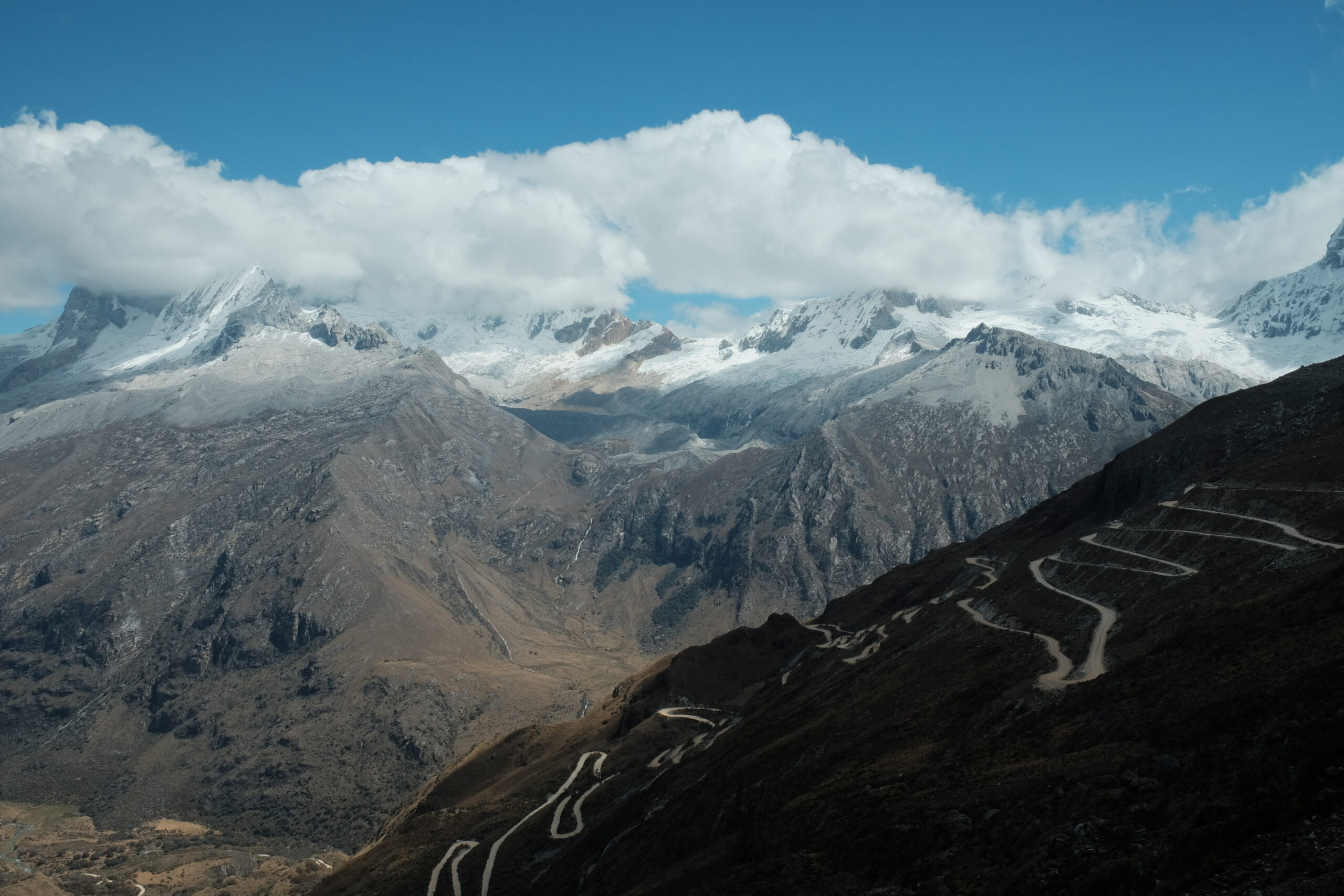
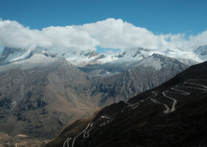
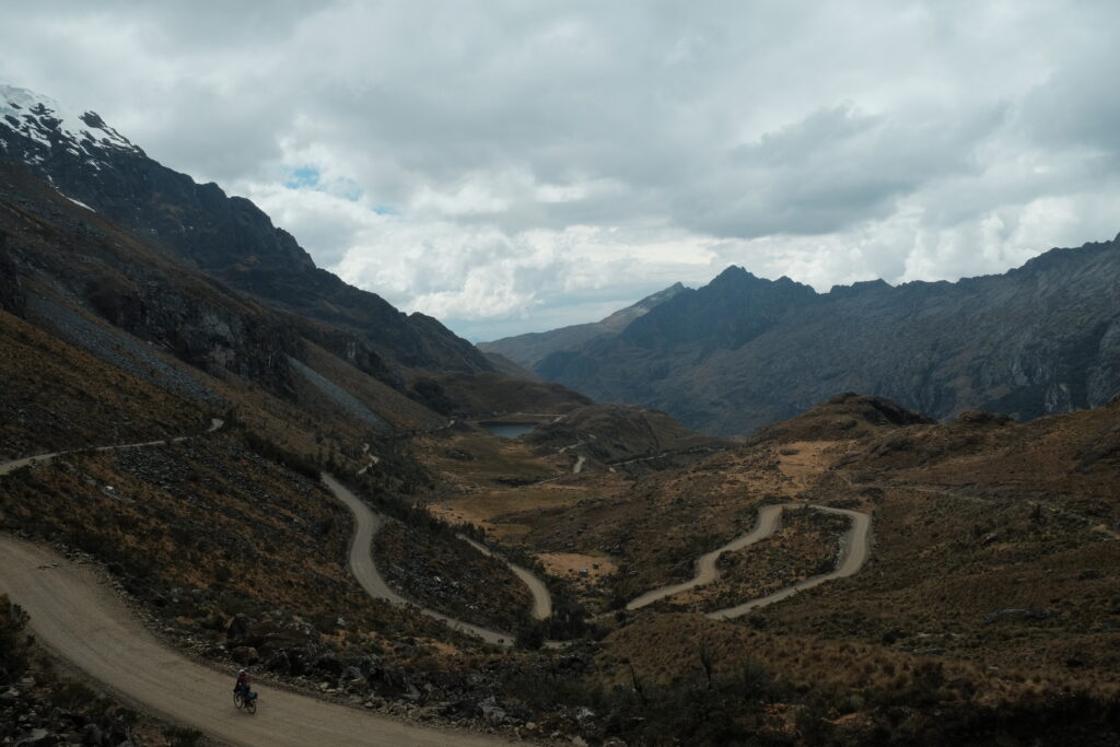
Thankfully Liam’s air mat held overnight and we awoke to another frosty morning in paradise. I love hiking and hill walking but find it much more challenging at altitude. I was glad to put the two feet chapter behind us and looked forward to be getting back on the bike that day, especially as we would be ascending one of bike touring’s most photogenic roads. The switchbacks out of the Llanganuco valley are something to behold and in the crisp morning air with views back across to the lakes you can’t help but feel lucky to be alive. There can’t be a rideable climb anywhere in the world where you get a view like this onto a 6,000m ice-capped mountain.


After ascending the photogenic switchbacks you pop through a notch cut through the rock at the top and cross into a valley that feels and looks totally different. No more tourists, and no more sun (for us!). For the latter I blame Liam who that morning had been trying to remember the last time we’d been rained on in the tent.


The infinite switchbacks made for a slow descent and it felt like lunch in Yanama would never arrive. When we eventually rolled into the mountain town it was completely devoid of human life. A combination of Sunday and a local football match meant the place was deserted! Fortunately we found somewhere open for hot food and just in the nick of time as it started to rain. We lingered over lunch waiting for the clouds to blow over, which they eventually did, but we went from having all afternoon to get over a little 600m lump to only having a couple of hours. The rain had intensified the smell of the eucalyptus and we were soon warm again winching our way up and into the next valley where we found a peaceful camp spot just below the pass. The following morning we had an amusing descent towards the valley floor getting stuck behind the morning rush hour of old women in hats walking their caravan of animals to a new grazing patch. One group had dogs, sheep, goats, cows and pigs with the matriarch casually spinning wool at the same time, clutching the spindle between her teeth.
The final pass on the Huascaran circuit is Punta Olympica and it is the only paved pass of the route. Sadly for us the weather had turned and while it wasn’t heavy rain it was enough to confine Liam’s camera to a dry bag. I was also starting to struggle, my stomach had not been right since arriving in Caraz and had been deteriorating, resulting in waves of cramps and some emergency dashing behind boulders. Bike touring is anything but glamorous.
The clouds would occasionally tease us by revealing the jagged snow and ice covered tops which surrounded us. We had a high, wet camp 7km from the tunnel at the top of the pass that revealed one of Liam’s panniers to no longer be waterproof. We’d been so lucky with the weather up until now that it was a bit of a reality check to be rained on two days in a row! We woke up to see a fresh dusting of snow on the slopes above us and the bottom of the glacier poking our from under the cloud.

The morning was a bit gloomy and with fog descending we allowed ourselves a lazy morning hoping the sun would burn it off. Thankfully the day did brighten up and we felt a lot safer having waited for visibility to improve. The tunnel at the top of Punta Olympica cuts about 200m from the overall climb. We had at one point toyed with the idea of going over the top on the old road but I was feeling weak and the road looked a bit dangerous so we layered and lit ourselves up and plunged into the 1400m long tunnel, the highest in the world at 4,680 meters above sea level.


The tunnel was actually quite terrifying as the noise of an oncoming car reverberated around the dark, wet, rocky cave. It felt like the light at the end of the tunnel couldn’t arrive quickly enough. When it finally arrived it was gloriously warm, bright and … sunny! A beautiful day on the other side of the rocky hill with soft white cloud surrounded by blue skies.

We kept our tunnel layers on as we had around 45km of downhill freewheeling ahead of us. Stopping only for lunch and undressing as we got lower and warmer.

Unfortunately around 8km from our final destination of Huaraz the heavens opened again and we got drenched. The only thing more unpleasant than riding in the pouring rain is riding on a busy road in the pouring rain. Huaraz arrived like a cacophony of engines, car horns, dogs barking and splashing puddle. We turned up at a hostel too cold and tired to haggle and were a little disappointed that the hot water advertised was more luke warm.
Our first destination, before a hot dinner, was the health centre where I was diagnosed with a Shigella infection and sent off with a cocktail of drugs and strict instructions to avoid raw fruit and vegetables for a few days… and I would need it for what is coming up.
Routes
If you’re interested in our routes, you can find them all on our trip homepage.
Your exploits have inspired my wife and I to do a bike tour. We are going to do The Rebellion Way a 240 mile loop of Norfolk.
Probably very similar to what you are experiencing.
Keep the stories and pictures coming.
Brings back incredibly fond memories riding through this area.
Glad to see much hasn’t changed!
I just read your post. We are currently in Chacas going the reverse of your route. Our weather has been a bit bettr than what you had. Hopefully the next few days back over the top improve. Are you in Bolivia yet? Keep well. Danny